Tuesday, March 30, 2010

Saturday, March 27, 2010
Marine Scientists dive into Google Earth
From Google Earth Blog
http://feedproxy.google.com/~r/GoogleEarthBlog/~3/6Ikiy3uCtN4/marine_scientists_dive_into_google.html
http://feedproxy.google.com/~r/GoogleEarthBlog/~3/6Ikiy3uCtN4/marine_scientists_dive_into_google.html
- Get your own blog app at MotherApp.com
Art Trembanis
CSHEL
Univ of Delaware
Playing games in Google Earth
From Google Earth Blog
http://feedproxy.google.com/~r/GoogleEarthBlog/~3/oyjXyjF1Ykg/playing_games_in_google_earth.html
http://feedproxy.google.com/~r/GoogleEarthBlog/~3/oyjXyjF1Ykg/playing_games_in_google_earth.html
- Get your own blog app at MotherApp.com
Art Trembanis
CSHEL
Univ of Delaware
A Google Earth flight sim with an iPhone controller
From Google Earth Blog
http://feedproxy.google.com/~r/GoogleEarthBlog/~3/Ifef9YzF5p8/a_google_earth_flight_sim_with_an_i.html
http://feedproxy.google.com/~r/GoogleEarthBlog/~3/Ifef9YzF5p8/a_google_earth_flight_sim_with_an_i.html
- Get your own blog app at MotherApp.com
Art Trembanis
CSHEL
Univ of Delaware
Thursday, March 25, 2010
ROV Simulator

Sent from my Verizon Wireless BlackBerry
Thursday, March 18, 2010
BBC News - Invisibility cloak created in 3-D
Just in time for Quidditch season!!
http://news.bbc.co.uk/2/hi/science/nature/8574923.stm
http://news.bbc.co.uk/2/hi/science/nature/8574923.stm
Art Trembanis
CSHEL
Univ of Delaware
Wednesday, March 17, 2010

Tuesday, March 9, 2010
GViz lab development

The videowall is being installed tomorrow. More photos to come.
Sent from my Verizon Wireless BlackBerry
Panoram display on the cheap
March 5, 2010 5:16 PM
by Kurt
Panoram display on the cheap
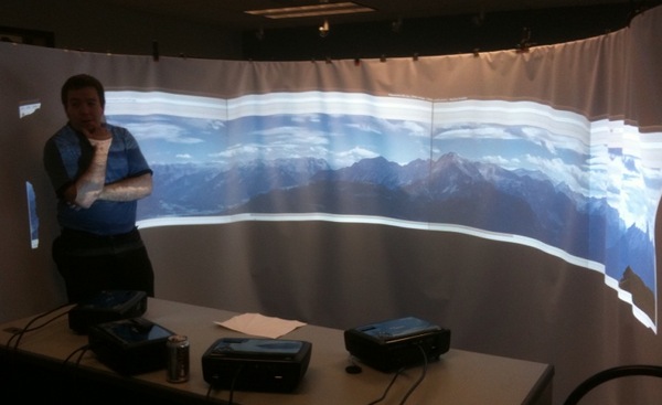
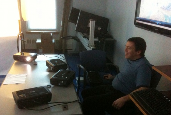
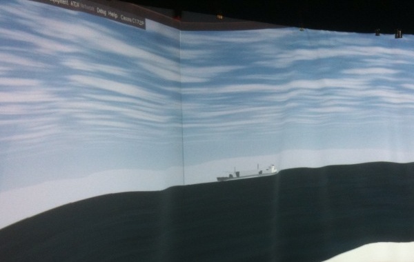
Roland and Colin setup the panoram display in the vislab using 4 projectors. Roland got the display up using static panoramas, GigaPan, and <a href="http://www.flightgear.org/">FlightGear</a>. <br /><br /> <img title="Roland showing off the 4 projectors" withgrayborder="True" src="http://schwehr.org/blog/attachments/2010-03/panoram-roland.jpg"/> <br /><br /> <img title="Roland at the controls" withgrayborder="True" src="http://schwehr.org/blog/attachments/2010-03/panoram-operating.jpg"/> <br /><br /> Being that flight gear is based on open source toolkits, there is a good chance that we can hook our AIS feed to this and drive the ships around to match actual traffic. <br /><br /> <img title="" withgrayborder="True" src="http://schwehr.org/blog/attachments/2010-03/panoram-flightsim-ship.jpg"/>
Art Trembanis
CSHEL
Univ of Delaware
Saturday, March 6, 2010
AUV Plankton Sampler
A few photos from a visit we had last week between folks from UD, Rutgers, and Cellula robotics.


Transatlantic pioneer | WHYY News and Information | WHYY
A WHYY story about the recent glider crossing of the Atlantic
http://whyy.org/cms/news/health-science/2010/03/05/transatlantic-pioneer/32669Tuesday, March 2, 2010
Chilean Earthquake Shortened Earth's Day
March 1, 2010 11:30 PM
by kdawson
Chilean Earthquake Shortened Earth's Day
ailnlv writes "Days on Earth just got shorter. The recent earthquake in Chile shifted the planet's axis by about 8 cm and shortened days by 1.26 microseconds 'The changes can be modeled, though they're difficult to detect physically given their small size... Some changes may be more obvious, and islands may have shifted... Santa Maria Island off the coast near Concepcion, Chile's second-largest city, may have been raised 2 meters (6 feet) as a result of the latest quake...'"
![]()
![]()
Read more of this story at Slashdot.
earth
Art Trembanis
CSHEL
Univ of Delaware
Monday, March 1, 2010
Project Noah: Networked Organisms and Habitats
What if we did a similar thing for geological features and marine habitats(thanks Doug Miller great idea)
March 1, 2010 1:30 PM
by Peter Horvath
Project Noah: Networked Organisms and Habitats

Project Noah is a free mobile application that nature lovers can use to explore and document local wildlife and a common technology platform that research groups can use to harness the power of citizen scientists everywhere. Noah stands for networked organisms and habitats.
Now available worldwide as an iPhone app in iTunes [iTunes link], Project Noah aims to become a common mobile platform for documenting the world's organisms. Beyond documentation, the iPhone app offers users an opportunity to participate in ongoing citizen science research projects through specifically designed field missions and can be used as a location-based field guide as well. All contributors are connected with an online community, bridging the documentation process.
The project has been picking up steam lately and has been featured by the Council for the Internet of Things, IBM's Smarter Planet, GOOD and is in pilot studies with schools for use as an educational tool.
Read more | Permalink | Comments | Read more articles in iPhone | Digg this!iPhone
Art Trembanis
CSHEL
Univ of Delaware
Subscribe to:
Posts (Atom)