http://www.udel.edu/udaily/2013/feb/rov-marine-research-022213.html
Sent from my iPhone
Saturday, February 23, 2013
Friday, February 15, 2013
Odds of Death by Asteroid? Lower Than Plane Crash, Higher Than Lightning
February 15, 2013 2:39 PM
by Adam Mann
Odds of Death by Asteroid? Lower Than Plane Crash, Higher Than Lightning
Most people in the U.S. woke up to a spectacular sight this morning: videos from Russian dashboard cameras showing a fireball in the sky crashing down to the Earth. The 15-meter meteorite impacted the atmosphere and exploded above the Chelyabinsk region of central Russia, injuring an estimated 1,200 people and causing roughly 1 billion rubles ($33 million U.S.) in damage. It was the largest meteorite to hit the country in more than a century.
Dr. Art Trembanis
Associate Professor
CSHEL
109 Penny Hall
The College of Earth, Ocean, and Environment
University of Delaware
Newark DE 19716
302-831-2498
"We shall not cease from exploration. And the end of all our exploring will be to arrive where we started and know the place for the first time."
-T. S. Eliot, Little Gidding
Reconstructing the Chelyabinsk meteor’s path, with Google Earth, YouTube and high-school math
February 15, 2013 8:11 PM
by Stefan Geens
Reconstructing the Chelyabinsk meteor's path, with Google Earth, YouTube and high-school math
Like many others, I was absolutely astounded by the meteor strike over Chelyabinsk when I woke on Friday morning. One silver lining to our self-surveilling society is that an event of this magnitude is certain to get caught on the myriad of always-on dashboard- and web cams. I for one could not get enough of the videos.
Might it be possible to use today's footage and Google Earth to have an initial go at mapping the meteorite's trajectory? I was pondering this question some 2,500km away from Chelyabinsk when I chanced upon this video:
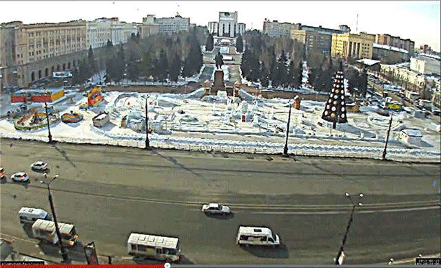
That place is easy to find — it's Revolution Square at the absolute center of Chelyabinsk, looking almost directly south. It is also easy to measure — the distance between the two central light poles is 32 meters, as per a quick measurement in Google Earth, while the five lanes of traffic going right to left (west to east) measure 19 meters. From this it is easy to estimate the height of the light poles to be around 12 meters — an estimate corroborated by numerous panoramas in Google Earth showing people next to these lamp posts, giving us added data points.
Using all this information, I was able to do some image analysis in Photoshop on the lengths and angles of the shadows as the meteor streaked across the sky. Here's an animated gif showing the result of that:
The ensuing grade-school mathematics (SOHCAHTOA!) resulted in three lines of sight at three instants a few seconds apart. (For the sake of the record, I roughly calculated them to be towards 122 degrees at an inclination of 33 degrees at 9:20:28.7, towards 187 degrees at an inclination of 40 degrees at 9:20:32.2, and towards 222 degrees at an inclination of 32 degrees at 9:20:33.4. These times are the video's own timeline, though they appear to correlate closely with the timelines of other videos.)
That allowed me to draw a plane in Google Earth which should include the meteor's path, though it does not allow me to know the distance of the meteor from Chelyabinsk or its speed.
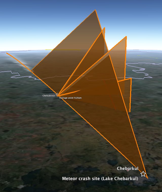
However, we have more clues. We know a fragment of the meteor landed in Lake Chebarkul, roughly 70km WSW of Chelyabinsk. Gratifyingly, the plane generated from the above video roughly intersects with the crash site. Also useful was the estimate by the Russian Academy of Sciences that the meteorite hit the Earth's atmosphere at around 50,000 km/h, shattering at an altitude of 30-50km. If that was the rough speed of the meteor as it burned up in the video, then the 4.7 seconds between the first and last shadow measurements would have seen it travel 65 km. Fitting a 65km line between these two lines of sight allows us to draw a straight line path for the meteor towards the crash site, with the first measured time yielding a height of 29km, which is the moment the meteor first brightened enough to give a clear shadow.
Download the visualizations for this as a KMZ file to open in Google Earth. Do play with the opacity slider of the overlay to check the alignments yourself — it's most of the fun.
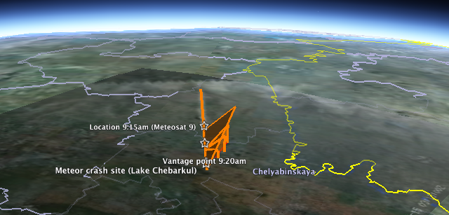
How does this data square with the Meteosat 9 image that has being doing the rounds? At first glance, not well: Overlaying the image in Google Earth and aligning the border with Kazakhstan shows a 240km contrail that appears to end some 75km to the ENE of Chelyabinsk, even though the path when traced on the ground also leads directly to Lake Chebarkul.
At first, I thought the image might have been taken 5 minutes earlier, before the meteor streaked straight across Chelyabinsk proper, because the image's metadata gives us a time of 3:15:00Z, or UTC, which is 6 hours behind Chelyabinsk time. But no meteor is going to take 5 minutes to traverse 75km, so we'll just have to live with the time discrepancy. Webcams are not atomic clocks.
Much more interesting is the fact that if you look at the position of Meteosat 9, which is in a geostationary orbit, you see that Chelyabinsk is near the horizon of its view of Earth. This leads to extreme foreshortening in the snapshot of the meteor's contrail:
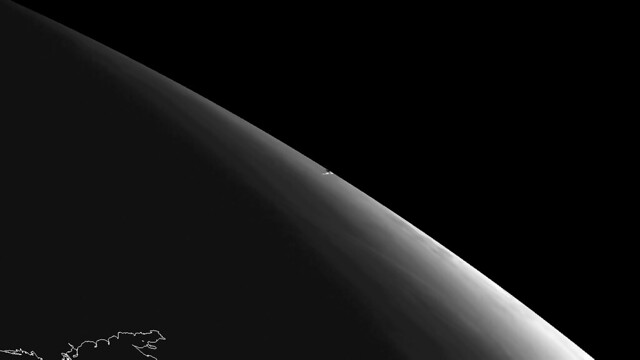
(Notice the outline of the Sea of Azov in the foreground. Here is another version showing the thermal impact.)
The version used in the overlay is an enhanced view of this image, taken from the same angle. (The blacked-out upper right-hand corner of the overlay is behind the horizon as seen from Meteosat 9.). If you simulate this view of Chelyabinsk in Google Earth, you see that in fact, the contrail aligns quite nicely over Chelyabinsk considering that it would be 30km high and at such an extreme angle over the horizon. So the 4.7 seconds of maximal brightness (with contrail) do get to happen just south of Chelyabinsk proper, as per the above video, and without contradiction by Meteosat 9.
I feel this post would not be complete without some big caveats: I am not a trained scientist; I don't know if meteors travel through the atmosphere in straight lines or at constant speeds (I assume they don't, but that it doesn't matter for back-of-the-envelope type calculations). Still, it is satisfying to know that with judicious use of Google Earth, YouTube and Photoshop you can get quite far in the meteor simulation game. I can't wait to see what the professionals come up with.
Uncategorized
Dr. Art Trembanis
Associate Professor
CSHEL
109 Penny Hall
The College of Earth, Ocean, and Environment
University of Delaware
Newark DE 19716
302-831-2498
"We shall not cease from exploration. And the end of all our exploring will be to arrive where we started and know the place for the first time."
-T. S. Eliot, Little Gidding
Monday, February 11, 2013
Google Earth and Virtual Visualizations in Geoscience Education and Research
Google Earth and Virtual Visualizations in Geoscience Education and Research
Google Earth Blog
 For those of you that like to dig deep into Google Earth, a new book from the Geological Society of America might be something you'll want to check out. The book is called Google Earth and Virtual Visualizations in Geoscience Education and Research, and it covers a wide variety of facets around Google Earth.
It includes content from a variety of writers that we've featured on Google Earth Blog over the years including Richard Treves, John Bailey, Mano Marks and Valery Hronusov. You can read the full table of contents to get a better feel for the content available in the book. The GSA describes it as follows:
GSA Special Paper 492 consists of 35 papers that collectively synthesize the development and current uses of Google Earth and associated visualization media in geoscience education and research. Chapters focus on Google Earth and related tools, such as SketchUp, Google Fusion Tables, GigaPan, and LiDAR. Many of these papers include digital media that illustrate and highlight important themes of the texts. This volume is intended to document the state of the art for geoscience applications of geobrowsers, such as Google Earth, along with providing provocative examples of where this technology is headed in the future.
If you're interested in learning more about the book or to purchase a copy, head over to the GSA Bookstore site.
Original Article: http://feedproxy.google.com/~r/GoogleEarthBlog/~3/Z1Jf9KecyTg/google_earth_and_virtual_visualizat.html
Sent from my iPhone
Wednesday, February 6, 2013
Invasive species among marine science subjects in Cayman Islands study abroad program
http://www.udel.edu/udaily/2013/feb/cayman-study-abroad-020613.html
Dr. Art Trembanis
Associate Professor
CSHEL
109 Penny Hall
The College of Earth, Ocean, and Environment
University of Delaware
Newark DE 19716
http://cshel.geology.udel.edu
302-831-2498
"We shall not cease from exploration. And the end of all our exploring will be to arrive where we started and know the place for the first time."
-T. S. Eliot, Little Gidding
"Il faut aller voir" -JYC
Tuesday, February 5, 2013
Powerful quake strikes in South Pacific, sparks tsunami - CNN.com
http://www.cnn.com/2013/02/05/world/asia/solomon-islands-quake/index.html?hpt=hp_t1
Dr. Art Trembanis
Associate Professor
CSHEL
109 Penny Hall
The College of Earth, Ocean, and Environment
University of Delaware
Newark DE 19716
http://cshel.geology.udel.edu
302-831-2498
"We shall not cease from exploration. And the end of all our exploring will be to arrive where we started and know the place for the first time."
-T. S. Eliot, Little Gidding
"Il faut aller voir" -JYC
Sunday, February 3, 2013
Friday, February 1, 2013
Great imagery of the Sakurajima Volcano in Japan
Great imagery of the Sakurajima Volcano in Japan
Google Earth Blog
With more than 680,000 residents within a few kilometers of it, scientists keep a close eye on Japan's Sakurajima Volcano. A few weeks ago a new advisory was put out for the volcano and an image was captured by NASA less than an hour later. In the image you can clearly see the plume trail stretching for many miles.

You can view this image in Google Earth by loading this KML file.
Because of the high-resolution base imagery in the area and the 3D terrain of Google Earth, the volcano looks quite amazing even without NASA's image laid on top of it. The imagery is from 2005, though the historical imagery in Google Earth offers part of the island with slightly newer imagery. In any case, it looks quite awesome.

You can read more about the volcano and this new imagery over on the NASA Earth Observatory site.
Original Article: http://feedproxy.google.com/~r/GoogleEarthBlog/~3/ZH6SWzXWd1s/great_imagery_of_the_sakurajima_vol.html
Sent from my iPhone
Subscribe to:
Posts (Atom)