Extra extra read all about it. Coastalcare.org article about the Redbird Reef site.
Saturday, June 8, 2013
An Ancient Beach With Modern Subway Cars- 16 Fathoms Down To Take This Train | Coastal Care
Thursday, June 6, 2013
Deep-Sea Dump: ROVs Expose Trashed Ocean Floor
Deep-Sea Dump: ROVs Expose Trashed Ocean Floor
Wired News
Instead of washing ashore, much of what we throw in the ocean stays there, slowly sinking to the bottom. Now, scientists at the Monterey Bay Aquarium Research Institute have compiled a report of deep-sea debris items, extending to depths of almost 12,000 feet.
Original Article: http://feeds.wired.com/~r/wired/index/~3/XDzUoZn04As/
Sent from my iPhone
Wednesday, June 5, 2013
“Sailing Alone Around the World” in Google Earth
Yammer schooner!!
"Sailing Alone Around the World" in Google Earth
Google Earth Blog
Colin Hazelhurst, who has built impressive tours such as Captain James Cook's exploration of Australia, is back with an amazing collection of tours that show the voyage of Captain Joshua Slocum in his book "Sailing Alone Around the World".

Captain Joshua Slocum is credited with making the first single-handed voyage around the world, departing from Boston in April, 1895 and arriving in Newport in June, 1898 after a journey of some forty-six thousand miles The animations presented on Colin's site are organized by the chapters of Slocum's book and within that into the significant passages that made up his voyage.
In addition to the impressive collection of narrated Google Earth tours that you can find on his website, Colin is also converting all of them into YouTube videos for easy viewing. As an example, here is Chapter III Part 3: "At Fayal in the Azores":
For more about this great collection of tours, you can follow Colin on Google+ or visit hazelhurst.com/Slocum to see all of the tours.
Great work Colin!
The post "Sailing Alone Around the World" in Google Earth appeared first on Google Earth Blog.
Original Article: http://feedproxy.google.com/~r/GoogleEarthBlog/~3/cz3t-oh0z6k/sailing-alone-around-the-world-in-google-earth.html
Sent from my iPhone
Tuesday, May 28, 2013
Monday, May 27, 2013
Chile issues volcano evacuation order
Chile issues volcano evacuation order
BBC News
The authorities in Chile order the evacuation of 2,240 people living near the Copahue volcano because of 'increased seismic activity'
Original Article: http://www.bbc.co.uk/news/world-latin-america-22684322#sa-ns_mchannel=rss&ns_source=PublicRSS20-sa
Sent from my iPhone
Saturday, May 25, 2013
Resource Protection - Potentially Polluting Wrecks in U.S. Waters
http://sanctuaries.noaa.gov/protect/ppw/
Report just out by NOAA listing wreck sites that could potentially release oil into the environment.
Report just out by NOAA listing wreck sites that could potentially release oil into the environment.

Wednesday, May 22, 2013
New NOAA report examines national oil pollution threat from shipwrecks
These are just the kinds of scenarios that an AUV based monitoring program is ideally well suited for and I'm not just speaking as an interested AUV party someone needs to do this.
May 20, 2013 11:00 AM
New NOAA report examines national oil pollution threat from shipwrecks
NOAA presented to the U.S. Coast Guard today a new report that finds that 36 sunken vessels scattered across the U.S. seafloor could pose an oil pollution threat to the nation's coastal marine resources.
noaa, coast guard, sunken, vessels, shipwrechks,sea floor, oil, pollution, threat, coast, resources.
Dr. Art Trembanis
Associate Professor
CSHEL
109 Penny Hall
The College of Earth, Ocean, and Environment
University of Delaware
Newark DE 19716
302-831-2498
"We shall not cease from exploration. And the end of all our exploring will be to arrive where we started and know the place for the first time."
-T. S. Eliot, Little Gidding
Friday, May 17, 2013
How underwater Street View works
How underwater Street View works
Google Earth Blog
Last September we showed you the first set of amazing underwater Street View images that Google had released. They were absolutely stunning, as you can see in the example here:

TechCrunch recently spoke with Google about their Ocean Street View program, and came away with some amazing insights, including:
…the cameras his team uses for this project are very different from those used by Google's other Street View vehicles. The team had to use wider-angle lenses, for example. Google's underwater Street View camera has three cameras on its front and takes images every three seconds. One of the cameras points downward, because that's how images during reef surveys have traditionally been taken. The back of the scooter features a tablet that can control the cameras.
During a typical dive, the divers cover about 2km and take 3,000 to 4,000 images per camera, and the team does three dives per day, each of which lasts about an hour. In total, the team has taken about 150,000 images so far, and Vevers expects this number to grow exponentially over the next few months. In the long run, the team hopes to create diver-less systems that can stay underwater for 12 hours or more. The technology is already available, but it needs to be adapted to the kind of camera system needed for Street View.
The systems cost around $50,000 each, and they're already testing 3D cameras to begin to capture that kind of imagery soon.

It's quite an amazing article, and it offers some great details into how this system works. Check out the full article, then explore our previous post on underwater Street View to visit some of these areas for yourself.
The post How underwater Street View works appeared first on Google Earth Blog.
Original Article: http://feedproxy.google.com/~r/GoogleEarthBlog/~3/8hw0cwCh7Og/how-underwater-street-view-works.html
Sent from my iPhone
Thursday, May 16, 2013
SoMAS - Benthic habitat and seafloor morphology mapping - YouTube
Folks at Stony Brook University School of Marine and Atmospheric Sciences invited me up to give a seminar last week and the talk has been recorded and posted to YouTube here.
http://www.youtube.com/watch?v=cj3U3V23sJQMonday, May 13, 2013
Sunday, May 5, 2013
Observed Atmospheric CO2 Hits 400 Parts Per Million
Observed Atmospheric CO2 Hits 400 Parts Per Million
Slashdot
symbolset writes "Over the past month a number of individual observations of CO2 at the Mauna Loa Observatory have exceeded 400 parts per million. The daily average observation has crept above 399 ppm, and as annually the peak is typically in mid-May it seems likely the daily observation will break the 400 ppm milestone within a few days. This measure of potent greenhouse gas in the atmosphere should spark renewed discussion about the use of fossil fuels. For the past few decades the annual peak becomes the annual average two or three years later, and the annual minimum after two or three years more."
Read more of this story at Slashdot.
Original Article: http://rss.slashdot.org/~r/Slashdot/slashdot/~3/ngoSXRDEnv8/story01.htm
Sent from my iPhone
Sunday, April 28, 2013
Astronaut’s Caravan at Maker Faire UK
April 28, 2013 12:11 PM
by Dale Dougherty
Astronaut's Caravan at Maker Faire UK
The amazing Tim Hunkin has done it again. In collaboration with Andy Plant, Tim has created the Astronaut's Caravan. It's a trailer that turns 360 degrees. Tim had the humorous idea of creating a place where former astronauts might go on holiday to recreate a bit of the experience of [...]


Art & Design
Dr. Art Trembanis
Associate Professor
CSHEL
109 Penny Hall
The College of Earth, Ocean, and Environment
University of Delaware
Newark DE 19716
302-831-2498
"We shall not cease from exploration. And the end of all our exploring will be to arrive where we started and know the place for the first time."
-T. S. Eliot, Little Gidding
Thursday, April 18, 2013
Shark-Stalking Robot Will Spy on Mysterious Ocean Predators | Wired Science | Wired.com
http://www.wired.com/wiredscience/2013/04/sharkbot/?utm_source=feedburner&utm_medium=feed&utm_campaign=Feed%3A+wired%2Findex+%28Wired%3A+Top+Stories%29&utm_content=Google+Feedfetcher
Dr. Art Trembanis
Associate Professor
CSHEL
109 Penny Hall
The College of Earth, Ocean, and Environment
University of Delaware
Newark DE 19716
http://cshel.geology.udel.edu
302-831-2498
"We shall not cease from exploration. And the end of all our exploring will be to arrive where we started and know the place for the first time."
-T. S. Eliot, Little Gidding
"Il faut aller voir" -JYC
Wednesday, April 17, 2013
Saturday, April 6, 2013
Robots, Deep-Sea Sensors Help Pentagon Futurists Hunt Subs | Danger Room | Wired.com
http://www.wired.com/dangerroom/2013/04/darpa-subs/?utm_source=feedburner&utm_medium=feed&utm_campaign=Feed%3A+wired%2Findex+%28Wired%3A+Top+Stories%29&utm_content=Google+Feedfetcher
Dr. Art Trembanis
Associate Professor
CSHEL
109 Penny Hall
The College of Earth, Ocean, and Environment
University of Delaware
Newark DE 19716
http://cshel.geology.udel.edu
302-831-2498
"We shall not cease from exploration. And the end of all our exploring will be to arrive where we started and know the place for the first time."
-T. S. Eliot, Little Gidding
"Il faut aller voir" -JYC
Monday, April 1, 2013
Explore Treasure Mode with Google Maps - YouTube
Cool I have to check this out when I get a moment.
Meanwhile we just got back from an offshore cruise creating our own treasure map of the conditions at the Redbird Reef artificial reef site.
Here you can see sunken Navy barge, tugboats, a fishing ship on it's side and over 50 sunken subway cars.
Ahoy!
Sunday, March 31, 2013
Wednesday, March 13, 2013
Wednesday, March 6, 2013

Tuesday, March 5, 2013
Europa's Oceans Might Taste Like Earth's Oceans
March 5, 2013 2:38 PM
by Adam Mann
Europa's Oceans Might Taste Like Earth's Oceans
The subsurface water on Jupiter?s moon Europa probably tastes like the water in Earth?s oceans. This is according to scientists who mapped the frozen moon in greater detail than ever before and discovered a new mineral on its surface. Their research suggests that if you could somehow get to the distant, tiny world, survive the deadly radiation at its surface, drill through its 100-km-thick icy shell, and drink the water without dying, the taste would be somewhat familiar.
Dr. Art Trembanis
Associate Professor
CSHEL
109 Penny Hall
The College of Earth, Ocean, and Environment
University of Delaware
Newark DE 19716
302-831-2498
"We shall not cease from exploration. And the end of all our exploring will be to arrive where we started and know the place for the first time."
-T. S. Eliot, Little Gidding
Monday, March 4, 2013
Additional Details on the Large Fireball Event over Russia on Feb. 15, 2013
http://neo.jpl.nasa.gov/news/fireball_130301.html
Dr. Art Trembanis
Associate Professor
CSHEL
109 Penny Hall
The College of Earth, Ocean, and Environment
University of Delaware
Newark DE 19716
http://cshel.geology.udel.edu
302-831-2498
"We shall not cease from exploration. And the end of all our exploring will be to arrive where we started and know the place for the first time."
-T. S. Eliot, Little Gidding
"Il faut aller voir" -JYC
Friday, March 1, 2013
Western Citizen Science
Thanks to Nick Wilkinson for passing along info about this effort to highlight and explore the facets and usage of citizen science.
Saturday, February 23, 2013
Friday, February 15, 2013
Odds of Death by Asteroid? Lower Than Plane Crash, Higher Than Lightning
February 15, 2013 2:39 PM
by Adam Mann
Odds of Death by Asteroid? Lower Than Plane Crash, Higher Than Lightning
Most people in the U.S. woke up to a spectacular sight this morning: videos from Russian dashboard cameras showing a fireball in the sky crashing down to the Earth. The 15-meter meteorite impacted the atmosphere and exploded above the Chelyabinsk region of central Russia, injuring an estimated 1,200 people and causing roughly 1 billion rubles ($33 million U.S.) in damage. It was the largest meteorite to hit the country in more than a century.
Dr. Art Trembanis
Associate Professor
CSHEL
109 Penny Hall
The College of Earth, Ocean, and Environment
University of Delaware
Newark DE 19716
302-831-2498
"We shall not cease from exploration. And the end of all our exploring will be to arrive where we started and know the place for the first time."
-T. S. Eliot, Little Gidding
Reconstructing the Chelyabinsk meteor’s path, with Google Earth, YouTube and high-school math
February 15, 2013 8:11 PM
by Stefan Geens
Reconstructing the Chelyabinsk meteor's path, with Google Earth, YouTube and high-school math
Like many others, I was absolutely astounded by the meteor strike over Chelyabinsk when I woke on Friday morning. One silver lining to our self-surveilling society is that an event of this magnitude is certain to get caught on the myriad of always-on dashboard- and web cams. I for one could not get enough of the videos.
Might it be possible to use today's footage and Google Earth to have an initial go at mapping the meteorite's trajectory? I was pondering this question some 2,500km away from Chelyabinsk when I chanced upon this video:
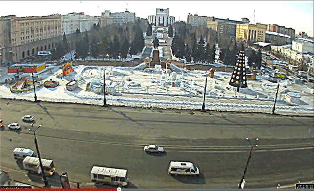
That place is easy to find — it's Revolution Square at the absolute center of Chelyabinsk, looking almost directly south. It is also easy to measure — the distance between the two central light poles is 32 meters, as per a quick measurement in Google Earth, while the five lanes of traffic going right to left (west to east) measure 19 meters. From this it is easy to estimate the height of the light poles to be around 12 meters — an estimate corroborated by numerous panoramas in Google Earth showing people next to these lamp posts, giving us added data points.
Using all this information, I was able to do some image analysis in Photoshop on the lengths and angles of the shadows as the meteor streaked across the sky. Here's an animated gif showing the result of that:
The ensuing grade-school mathematics (SOHCAHTOA!) resulted in three lines of sight at three instants a few seconds apart. (For the sake of the record, I roughly calculated them to be towards 122 degrees at an inclination of 33 degrees at 9:20:28.7, towards 187 degrees at an inclination of 40 degrees at 9:20:32.2, and towards 222 degrees at an inclination of 32 degrees at 9:20:33.4. These times are the video's own timeline, though they appear to correlate closely with the timelines of other videos.)
That allowed me to draw a plane in Google Earth which should include the meteor's path, though it does not allow me to know the distance of the meteor from Chelyabinsk or its speed.
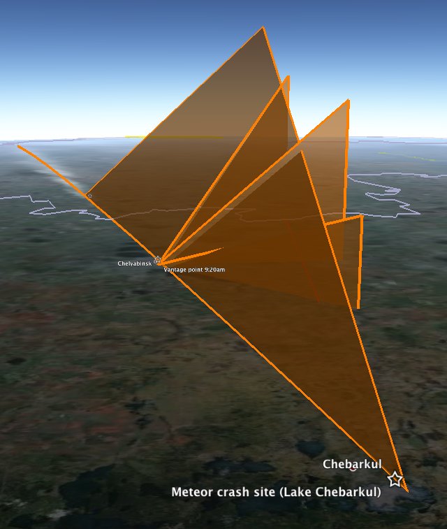
However, we have more clues. We know a fragment of the meteor landed in Lake Chebarkul, roughly 70km WSW of Chelyabinsk. Gratifyingly, the plane generated from the above video roughly intersects with the crash site. Also useful was the estimate by the Russian Academy of Sciences that the meteorite hit the Earth's atmosphere at around 50,000 km/h, shattering at an altitude of 30-50km. If that was the rough speed of the meteor as it burned up in the video, then the 4.7 seconds between the first and last shadow measurements would have seen it travel 65 km. Fitting a 65km line between these two lines of sight allows us to draw a straight line path for the meteor towards the crash site, with the first measured time yielding a height of 29km, which is the moment the meteor first brightened enough to give a clear shadow.
Download the visualizations for this as a KMZ file to open in Google Earth. Do play with the opacity slider of the overlay to check the alignments yourself — it's most of the fun.
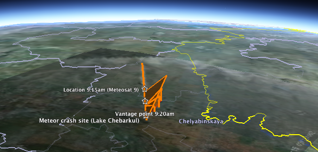
How does this data square with the Meteosat 9 image that has being doing the rounds? At first glance, not well: Overlaying the image in Google Earth and aligning the border with Kazakhstan shows a 240km contrail that appears to end some 75km to the ENE of Chelyabinsk, even though the path when traced on the ground also leads directly to Lake Chebarkul.
At first, I thought the image might have been taken 5 minutes earlier, before the meteor streaked straight across Chelyabinsk proper, because the image's metadata gives us a time of 3:15:00Z, or UTC, which is 6 hours behind Chelyabinsk time. But no meteor is going to take 5 minutes to traverse 75km, so we'll just have to live with the time discrepancy. Webcams are not atomic clocks.
Much more interesting is the fact that if you look at the position of Meteosat 9, which is in a geostationary orbit, you see that Chelyabinsk is near the horizon of its view of Earth. This leads to extreme foreshortening in the snapshot of the meteor's contrail:
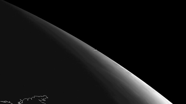
(Notice the outline of the Sea of Azov in the foreground. Here is another version showing the thermal impact.)
The version used in the overlay is an enhanced view of this image, taken from the same angle. (The blacked-out upper right-hand corner of the overlay is behind the horizon as seen from Meteosat 9.). If you simulate this view of Chelyabinsk in Google Earth, you see that in fact, the contrail aligns quite nicely over Chelyabinsk considering that it would be 30km high and at such an extreme angle over the horizon. So the 4.7 seconds of maximal brightness (with contrail) do get to happen just south of Chelyabinsk proper, as per the above video, and without contradiction by Meteosat 9.
I feel this post would not be complete without some big caveats: I am not a trained scientist; I don't know if meteors travel through the atmosphere in straight lines or at constant speeds (I assume they don't, but that it doesn't matter for back-of-the-envelope type calculations). Still, it is satisfying to know that with judicious use of Google Earth, YouTube and Photoshop you can get quite far in the meteor simulation game. I can't wait to see what the professionals come up with.
Uncategorized
Dr. Art Trembanis
Associate Professor
CSHEL
109 Penny Hall
The College of Earth, Ocean, and Environment
University of Delaware
Newark DE 19716
302-831-2498
"We shall not cease from exploration. And the end of all our exploring will be to arrive where we started and know the place for the first time."
-T. S. Eliot, Little Gidding
Monday, February 11, 2013
Google Earth and Virtual Visualizations in Geoscience Education and Research
Google Earth and Virtual Visualizations in Geoscience Education and Research
Google Earth Blog
 For those of you that like to dig deep into Google Earth, a new book from the Geological Society of America might be something you'll want to check out. The book is called Google Earth and Virtual Visualizations in Geoscience Education and Research, and it covers a wide variety of facets around Google Earth.
It includes content from a variety of writers that we've featured on Google Earth Blog over the years including Richard Treves, John Bailey, Mano Marks and Valery Hronusov. You can read the full table of contents to get a better feel for the content available in the book. The GSA describes it as follows:
GSA Special Paper 492 consists of 35 papers that collectively synthesize the development and current uses of Google Earth and associated visualization media in geoscience education and research. Chapters focus on Google Earth and related tools, such as SketchUp, Google Fusion Tables, GigaPan, and LiDAR. Many of these papers include digital media that illustrate and highlight important themes of the texts. This volume is intended to document the state of the art for geoscience applications of geobrowsers, such as Google Earth, along with providing provocative examples of where this technology is headed in the future.
If you're interested in learning more about the book or to purchase a copy, head over to the GSA Bookstore site.
Original Article: http://feedproxy.google.com/~r/GoogleEarthBlog/~3/Z1Jf9KecyTg/google_earth_and_virtual_visualizat.html
Sent from my iPhone
Wednesday, February 6, 2013
Invasive species among marine science subjects in Cayman Islands study abroad program
http://www.udel.edu/udaily/2013/feb/cayman-study-abroad-020613.html
Dr. Art Trembanis
Associate Professor
CSHEL
109 Penny Hall
The College of Earth, Ocean, and Environment
University of Delaware
Newark DE 19716
http://cshel.geology.udel.edu
302-831-2498
"We shall not cease from exploration. And the end of all our exploring will be to arrive where we started and know the place for the first time."
-T. S. Eliot, Little Gidding
"Il faut aller voir" -JYC
Tuesday, February 5, 2013
Powerful quake strikes in South Pacific, sparks tsunami - CNN.com
http://www.cnn.com/2013/02/05/world/asia/solomon-islands-quake/index.html?hpt=hp_t1
Dr. Art Trembanis
Associate Professor
CSHEL
109 Penny Hall
The College of Earth, Ocean, and Environment
University of Delaware
Newark DE 19716
http://cshel.geology.udel.edu
302-831-2498
"We shall not cease from exploration. And the end of all our exploring will be to arrive where we started and know the place for the first time."
-T. S. Eliot, Little Gidding
"Il faut aller voir" -JYC
Sunday, February 3, 2013
Friday, February 1, 2013
Great imagery of the Sakurajima Volcano in Japan
Great imagery of the Sakurajima Volcano in Japan
Google Earth Blog
With more than 680,000 residents within a few kilometers of it, scientists keep a close eye on Japan's Sakurajima Volcano. A few weeks ago a new advisory was put out for the volcano and an image was captured by NASA less than an hour later. In the image you can clearly see the plume trail stretching for many miles.

You can view this image in Google Earth by loading this KML file.
Because of the high-resolution base imagery in the area and the 3D terrain of Google Earth, the volcano looks quite amazing even without NASA's image laid on top of it. The imagery is from 2005, though the historical imagery in Google Earth offers part of the island with slightly newer imagery. In any case, it looks quite awesome.

You can read more about the volcano and this new imagery over on the NASA Earth Observatory site.
Original Article: http://feedproxy.google.com/~r/GoogleEarthBlog/~3/ZH6SWzXWd1s/great_imagery_of_the_sakurajima_vol.html
Sent from my iPhone
Subscribe to:
Posts (Atom)