Wednesday, November 30, 2011

Autonomous Ocean-Crossing Robots Launched

Autonomous Ocean-Crossing Robots Launched
starMAKE
November 30, 2011 4:00 PM
by Sean Michael Ragan

Autonomous Ocean-Crossing Robots Launched

Here's a clip of Liquid Robotics founder and CTO Roger Hine talking, at the most recent Bay Area Maker Faire, about the innovative design of his company's Wave Glider robot boat, which converts the up-and-down motion of waves at the surface into energy for propulsion. More technical details are available on Liquid Robotics' site.

On November 17, Liquid Robotics launched four Wave Gliders from San Francisco, and are currently streaming data from several on-board instruments, at a resolution of one or two reports per minute, in near-real-time, via the Iridium satellite network. Those data are freely available here.

All four Wave Gliders are bound for Hawaii, where they will split into two pairs, one of which will head to Japan, and the other to Australia. IEEE Spectrum is reporting that Liquid Robotics "aims to break the Guinness world record for longest unmanned ocean voyage" with the trip, though I have not been able to confirm that Guinness actually has such a record currently established, nor what it may be. [Thanks, Glen!]

More:
Record-vying transatlantic robot submarine at sea

GPS Robotics Science


Dr. Art Trembanis
Associate Professor
CSHEL
109 Penny Hall
Department of Geological Sciences
The College of Earth, Ocean, and Environment
University of Delaware
Newark DE 19716
302-831-2498
"We shall not cease from exploration. And the end of all our exploring will be to arrive where we started and know the place for the first time."
-T. S. Eliot, Little Gidding

"Il faut aller voir" -JYC

The American Denial of Global Warming - YouTube

I saw Professor Oreskes give a very similar talk on this subject at the ESTCP symposium and it was very enlightening.

http://www.youtube.com/watch?v=2T4UF_Rmlio

Seamless Topographic USGS maps | Google Earth Blog

http://www.gearthblog.com/blog/archives/2011/11/seamless_topographic_usgs_maps.html?utm_source=dlvr.it&utm_medium=facebook

Saturday, November 26, 2011

Google Earth Applications, Demos, Examples

http://www.epic.noaa.gov/talks/nns/forums/google.html

Lots of great google earth examples and demo file links here.

ERDDAP - Home Page

http://coastwatch.pfeg.noaa.gov/erddap/index.html

Thanks to Kurt for posting about this system. The list of datasets is impressive on a first glance there are lots of ones we can use in various projects though I didn't notice the WaveWatch III model which is quite handy for waves and winds for the kind of scour model set up we want to do for the Navy. Going to have to look through further for wave products. I saw coastal relief products in there.

Could be some handy sources of data for the nascent AUV mission web portal that we are working on.

Thursday, November 24, 2011

Stanford's Free Computer Science Courses

Stanford's Free Computer Science Courses
starSlashdot
November 23, 2011 6:33 PM
by samzenpus

Stanford's Free Computer Science Courses


mikejuk writes "Stanford University is offering the online world more of its undergraduate level CS courses. These free courses consist of You Tube videos with computer-marked quizzes and programming assignments. The ball had been started rolling by Sebastian Thrun and Peter Norvig's free online version of their Stanford AI class, for which they hoped to reach an audience in the order of a hundred thousand, a target which they seem to have achieved. As well as the previously announced Machine learning course you can now sign up to any of: Computer Science 101, Software as a Service, Human-Computer Interaction, Natural Language Processing, Game Theory, Probabilistic Graphical Models, Cryptography and Design and Analysis of Algorithms. Almost a complete computer science course and they are adding more. Introductory videos and details are available from each courses website."

Read more of this story at Slashdot.

education


Dr. Art Trembanis
Associate Professor
CSHEL
109 Penny Hall
Department of Geological Sciences
The College of Earth, Ocean, and Environment
University of Delaware
Newark DE 19716
302-831-2498
"We shall not cease from exploration. And the end of all our exploring will be to arrive where we started and know the place for the first time."
-T. S. Eliot, Little Gidding

"Il faut aller voir" -JYC

Wednesday, November 23, 2011

Takayama_HRI2008_RobotJobs

http://chime.stanford.edu/downloads/takayama_beyond_dirty_HRI2008_prepress.pdf

Interesting study on perceptions of robots for tasks.

Fwd: Call for Papers for new journal: Methods in Oceanography


Dr. Art Trembanis
Associate Professor
CSHEL
109 Penny Hall
Department of Geological Sciences
The College of Earth, Ocean, and Environment
University of Delaware
Newark DE 19716
302-831-2498
"We shall not cease from exploration. And the end of all our exploring will be to arrive where we started and know the place for the first time."
-T. S. Eliot, Little Gidding

"Il faut aller voir" -JYC


Begin forwarded message:

From: "Elsevier Aquatic Sciences" <stjournals@elsevier.dmsx.net>
Date: November 23, 2011 8:34:29 AM EST
To: art@UDel.Edu
Subject: Call for Papers  for new journal: Methods in Oceanography
Reply-To: "Elsevier Aquatic Sciences" <stjournals-EMID0AA01CR0H3G0297P5032TL2011JBGBT@elsevier.dmsx.net>

New Journal: Methods in Oceanography

Please click on this link to view the online version of this message

 
   New Journal: Methods in Oceanography


coverDear Dr. Trembanis,

We are pleased to announce that a new journal, Methods in Oceanography, will be launched in spring 2012.

Published on a quarterly basis, Methods in Oceanography solicits articles that document advances in pragmatic approaches to revealing new information about the oceans. This includes the fabrication and testing of new instruments, significant advances in the development of new methods for the interpretation of either existing or future data, as well as the development of new platforms and plans for ocean sampling. 

Special issues will be dedicated to frontiers in oceanography methods that relate to contemporary issues.  Review articles, by authoritative leaders, will document the history, contemporary status, and future potential for developing new methods in all aspects of oceanographic research.

Detailed information, including the online submission system can be found at www.elsevier.com/locate/mio.

Register NOW to receive updates and an alert when the first issue is live on Sciverse ScienceDirect (Volume 1: Issue 1 will have free online access).

Any questions? Please contact me.

Yours sincerely,
Dr. Christiane Barranguet
Executive Publisher Methods in Oceanography
c.barranguet@elsevier.com


Editor-in-Chief

Jules Jaffe
Scripps Institution of Oceanography,
UC San Diego

Register for Volume/Issue Alerts

Submit your paper

EES


For more information: www.elsevier.com

DATA PROTECTION NOTICE

This email has been sent to art@udel.edu from Elsevier B.V., Radarweg 29, 1043 NX Amsterdam, The Netherlands, using 22 Times B.V. technology and platform. This is a one-off email sent to you in the belief that it will be of interest.

We will not add your name and email address to our database unless you request further information. If you wish to ensure that you will not receive a future marketing message from us about these products or services, please send a reply message to exclusionlist@elsevier.com.
We respect your privacy and do not rent or sell your personal information to any non-affiliated third parties without your consent, except as may be stated in our privacy policy at: Elsevier privacy policy.

For the 22 Times privacy policy, please visit: 22 Times B.V. privacy policy.

We obtained your name and email address from ISI Thomson Scientific, 3501 Market street, Philadelphia, PA 19104 USA. If you wish to be removed from the ISI Thomson Scientific mailing lists, please click here ISI Thomson Scientific.

Copyright © 2011 Elsevier B.V. http://www.elsevier.com. registered office: Radarweg 29, 1043 NX Amsterdam, The Netherlands, under number 33156677, VAT number 002967455B65. All rights reserved.


Robots Attempting Longest Ever Unmanned Sailing Voyage - Science News - redOrbit

http://www.redorbit.com/news/science/1112426529/robots-attempting-longest-ever-unmanned-sailing-voyage/


Dr. Art Trembanis
Associate Professor
CSHEL
109 Penny Hall
Department of Geological Sciences
The College of Earth, Ocean, and Environment
University of Delaware
Newark DE 19716
http://cshel.geology.udel.edu
302-831-2498
"We shall not cease from exploration. And the end of all our exploring will be to arrive where we started and know the place for the first time."
-T. S. Eliot, Little Gidding

"Il faut aller voir" -JYC

Monday, November 21, 2011

The Problem With Landing Humans on Mars (and How to Fix It) | Wired Science | Wired.com

http://m.wired.com/wiredscience/2011/11/landing-on-mars/?utm_source=feedburner&utm_medium=feed&utm_campaign=Feed%3A+wired%2Findex+%28Wired%3A+Index+3+%28Top+Stories+2%29%29&utm_content=Google+Feedfetcher


Dr. Art Trembanis
Associate Professor
CSHEL
109 Penny Hall
Department of Geological Sciences
The College of Earth, Ocean, and Environment
University of Delaware
Newark DE 19716
http://cshel.geology.udel.edu
302-831-2498
"We shall not cease from exploration. And the end of all our exploring will be to arrive where we started and know the place for the first time."
-T. S. Eliot, Little Gidding

"Il faut aller voir" -JYC

Exploring the earth with NASA and Google Earth Portable

Exploring the earth with NASA and Google Earth Portable
starGoogle Earth Blog
November 21, 2011 8:03 AM
by Google Earth Blog

Exploring the earth with NASA and Google Earth Portable

We've told you about Google Earth Portable before, a small server with pre-loaded Google Earth data on it that allows Google Earth access in remote areas.

While it's often used in disaster situations, it can also be used for conducting research in areas that are far from internet connectivity. A great example of that is a project that Google and NASA conducted at Kelly Lake in British Columbia.

lake.jpg

Discovery Channel has a great video that features Googler Sean Maday (who has shown us some cool Google Earth Plug-in tools in the past). The video isn't embeddable, but you can watch it here on the Discovery Channel site.

Environment


Dr. Art Trembanis
Associate Professor
CSHEL
109 Penny Hall
Department of Geological Sciences
The College of Earth, Ocean, and Environment
University of Delaware
Newark DE 19716
302-831-2498
"We shall not cease from exploration. And the end of all our exploring will be to arrive where we started and know the place for the first time."
-T. S. Eliot, Little Gidding

"Il faut aller voir" -JYC

Mapping Benthic Habitats in Delaware Bay and the Coastal Atlantic: Acoustic Techniques Provide Greater Coverage and High Resolution in Complex, Shallow-Water Environments

Woo hoo congrats to Nicole her paper is available now from Estuaries and Coasts

http://www.springerlink.com/content/d38unq3r574256j7/about/

Friday, November 18, 2011

High Resolution Global Topographic Map of Moon

High Resolution Global Topographic Map of Moon
Better than the available coverage we have for the earth (the wet parts at least)!

starSlashdot
November 18, 2011 8:06 AM
by samzenpus

High Resolution Global Topographic Map of Moon


stuckinarut writes "NASA's Lunar Reconnaissance Orbiter has released the highest resolution near-global topographic map of the moon ever created. From the article: '"Our new topographic view of the moon provides the dataset that lunar scientists have waited for since the Apollo era," says Mark Robinson, Principal Investigator of the Lunar Reconnaissance Orbiter Camera from Arizona State University in Tempe. "We can now determine slopes of all major geologic terrains on the moon at 100 meter scale. Determine how the crust has deformed, better understand impact crater mechanics, investigate the nature of volcanic features, and better plan future robotic and human missions to the moon."'"

Read more of this story at Slashdot.

moon


Dr. Art Trembanis
Associate Professor
CSHEL
109 Penny Hall
Department of Geological Sciences
The College of Earth, Ocean, and Environment
University of Delaware
Newark DE 19716
302-831-2498
"We shall not cease from exploration. And the end of all our exploring will be to arrive where we started and know the place for the first time."
-T. S. Eliot, Little Gidding

"Il faut aller voir" -JYC

Follow robotic wave gliders on a record setting Pacific crossing in Google Earth

Go wave gliders go!
http://feedproxy.google.com/~r/blogspot/SbSV/~3/kR9WeJSlp2I/follow-robotic-wave-gliders-on-record.html

Exploring Mauna Loa in Google Earth

http://feedproxy.google.com/~r/GoogleEarthBlog/~3/d0N1vjDyTLA/exploring_mauna_loa_in_google_earth.html

Wednesday, November 16, 2011

Daily Planet : November 09, 2011 : Part 1

Great segment about Pavilion Lake and Google Earth featuring Sean Maday from the Google Ocean team.

http://watch.discoverychannel.ca/daily-planet/november-2011/daily-planet---november-09-2011/#clip564921

Underwater robot time machine: SeaMonster interviews Dr. Mark Patterson | SeaMonster

Check out this interview of our pal and fellow AUV enthusiast Dr. Mark Patterson.

http://theseamonster.net/2011/11/underwater-robot-time-machine-seamonster-interviews-dr-mark-patterson/

Ideas Are Just a Multiplier of Execution

http://www.oreillynet.com/onlamp/blog/2005/08/ideas_are_just_a_multiplier_of.html

Duke University unveils an excellent 3D Campus Map

Duke University unveils an excellent 3D Campus Map
starGoogle Earth Blog
November 16, 2011 7:52 AM
by Google Earth Blog

Duke University unveils an excellent 3D Campus Map

Similar to other colleges we've shown you in the past, such as Northeastern University, Duke University has just unveiled their new 3D campus map and it's quite impressive.

duke.jpg

With the help of concept3D, the map has become an excellent source of information for the school. Powered by the Concept3D "CampusBird Atlas" CMS, Duke staff can edit the map and publish new information on their own. In addition, all data is mirrored between the Google Earth Plugin API and the Google Maps API on the site; it appears seamless to the end user, but it's a tricky piece of work on the back end.

The map includes 3D models of 325 buildings across the campuses. The map also includes satellite views and traditional two-dimensional street maps and offers overlays that display details such as dining locations and parking permit requirements, photos related to the buildings and videos linked to specific campus locations.

The maps are only accessible via the Plugin (no downloadable KML), and you can view the new map here on the Duke website. In addition, the map is fully functional on mobile devices.

For new students or visitors that are trying to find their way around campus, tools like this must be incredibly helpful for them!

You can learn more about this great new map over on the concept3D blog.

3D Models


Dr. Art Trembanis
Associate Professor
CSHEL
109 Penny Hall
Department of Geological Sciences
The College of Earth, Ocean, and Environment
University of Delaware
Newark DE 19716
302-831-2498
"We shall not cease from exploration. And the end of all our exploring will be to arrive where we started and know the place for the first time."
-T. S. Eliot, Little Gidding

"Il faut aller voir" -JYC

The long-awaited text from Mark Atherton. « Echoes & Images by Mark W. Atherton

http://echoesandimages.com/

Thanks to Vince Capone for pointing me to this new encyclopedia of side-scan sonar images.

Monday, November 14, 2011

iPhone Acoustic Ruler

iPhone Acoustic Ruler
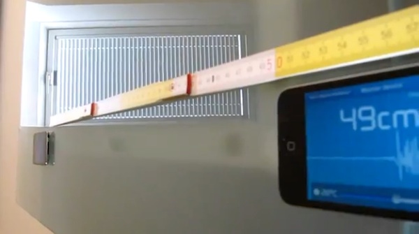
Cool video of the iPhone app for acoustic travel measurement.

starMAKE
November 14, 2011 5:00 AM
by Adam Flaherty

iPhone Acoustic Ruler

Here's a novel way to take measurements using sound waves with an iPhone. German developer Florian Student's Acoustic Ruler Pro for iOS will measure distances up to 25 meters by clocking the time delay of emitted sound waves. You can use the app with either a pair of headphones or with another iPhone to measure the distance between the two handsets. [via /.]

Cellphones iPhone Mobile Toolbox


Dr. Art Trembanis
Associate Professor
CSHEL
109 Penny Hall
Department of Geological Sciences
The College of Earth, Ocean, and Environment
University of Delaware
Newark DE 19716
302-831-2498
"We shall not cease from exploration. And the end of all our exploring will be to arrive where we started and know the place for the first time."
-T. S. Eliot, Little Gidding

"Il faut aller voir" -JYC

Friday, November 11, 2011

Robotic Fish Uses only One Servo

Robotic Fish Uses only One Servo
starMAKE
November 7, 2011 2:00 PM
by Michael Colombo

Robotic Fish Uses only One Servo

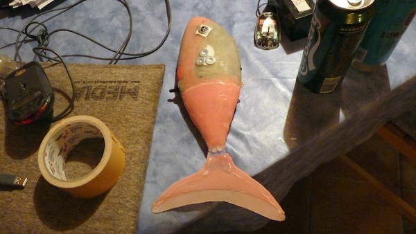
At the Center for Biorobotics in Estonia, Eszter Ozsvald built a mechanical fish named A.riel that can model the movements of actual fish surprisingly well while using only one servo inside a carefully made silicon-based mold. It took many iterations before her final product emerged, but found that in the end she could develop the same vortex patterns as actual fish. Her site has extensive documentation of the build process.

More:

Biology DIY Projects Mechanics Robotics biomimicry fish mold


Dr. Art Trembanis
Associate Professor
CSHEL
109 Penny Hall
Department of Geological Sciences
The College of Earth, Ocean, and Environment
University of Delaware
Newark DE 19716
302-831-2498
"We shall not cease from exploration. And the end of all our exploring will be to arrive where we started and know the place for the first time."
-T. S. Eliot, Little Gidding

"Il faut aller voir" -JYC