Art Trembanis
CSHEL
Univ of Delaware
Tuesday, December 29, 2009
Convert an Address to Latitude and Longitude - Wired How-To Wiki
http://howto.wired.com/wiki/Convert_an_Address_to_Latitude_and_Longitude?utm_source=feedburner&utm_medium=feed&utm_campaign=Feed%3A+wired%2Findex+%28Wired%3A+Index+3+%28Top+Stories+2%29%29&utm_content=Google+Feedfetcher
Saturday, December 26, 2009
The Known Universe by AMNH
A very cool visualization of the universe.
Check out this video on YouTube:
Check out this video on YouTube:
http://www.youtube.com/watch?v=17jymDn0W6U&feature=youtube_gdata
Art Trembanis
CSHEL
Univ of Delaware
Wednesday, December 23, 2009
7 Tipping Points That Could Transform Earth | Wired Science | Wired.com
The First Robot To Cross the Atlantic Ocean
December 20, 2009 10:46 PM
by kdawson
The First Robot To Cross the Atlantic Ocean
Hugh Pickens writes "She was at sea for 221 days, alone, often in dangerous places, and usually out of touch. Most of the time she was out of contact underwater, moving slowly up and down to depths of 600 feet, safe from ships, nets, and storms. Her predecessor had disappeared on a similar trip, probably killed by a shark. 'She was a hero,' says Rutgers University oceanographer Scott Glenn after retrieving Scarlet Knight, the 7-foot-9-inch submersible robot from the stormy Atlantic off western Spain. An engineer working for the company that made the submersible said, 'We think this will just be a precursor, like Lindbergh's trip across the Atlantic. In a decade we think it will be commonplace to have roving fleets of these gliders making transoceanic trips.' The people responsible for building, funding, and flying Scarlet hope the end of the robot's successful voyage will mark a new beginning in ocean and climate research. From its position at each surfacing — when the glider surfaced and called home via an Iridium telephone parked in its tail — researchers could calculate the net effect of currents deep and shallow. After surface currents were measured, the scientists could then make inferences about what was happening deeper in the water column. Scarlet called home to upload data to researchers three times a day. 'When we have hundreds of them, or thousands of them, it will revolutionize how we can observe the oceans,' says Jerry L. Miller, a senior policy analyst at the White House Office of Science and Technology Policy, who accompanied the research team to Spain."
Read more of this story at Slashdot.
earth
Art Trembanis
CSHEL
Univ of Delaware
Sunday, December 20, 2009
First Ever Video of Deep-Sea Volcanic Eruption
December 17, 2009 10:03 PM
by Alexis Madrigal
First Ever Video of Deep-Sea Volcanic Eruption
For the first time, scientists have watched molten lava flowing on the sea floor and creating new crust. And lucky for us, they caught it on video.
Art Trembanis
CSHEL
Univ of Delaware
Friday, December 18, 2009
SeaTalk Video - AUV | SeaGrant
http://deseagrant.org/seatalk/seatalk-video-auv
Art Trembanis
CSHEL
Univ of Delaware
Friday, December 11, 2009
NOAA Photo Library - America's Coastlines
A great resource for teaching and illustrating coastal features
Wednesday, December 9, 2009
Dr. Marshall Orr (NRL) visit to MIMO system in the test tank

Saturday, December 5, 2009
Glider crosses Atlantic
Thanks to Jon for pointing out this story.
http://m.gizmodo.com/site?sid=gizmodoip&pid=JuicerHub&targetUrl=http%3A%2F%2Fgizmodo.com%2F5419070%2Frobotic-sea%2Bglider-achieves-first-unmanned-underwater-transatlantic-crossing%3Fop%3Dpost%26refId%3D5419070
http://m.gizmodo.com/site?sid=gizmodoip&pid=JuicerHub&targetUrl=http%3A%2F%2Fgizmodo.com%2F5419070%2Frobotic-sea%2Bglider-achieves-first-unmanned-underwater-transatlantic-crossing%3Fop%3Dpost%26refId%3D5419070
Art Trembanis
CSHEL
Univ of Delaware
Wednesday, December 2, 2009
CSHEL @ Geospatial Research Day
A photo from the talk entitled
given at the 1st Geospatial Research Day Symposium
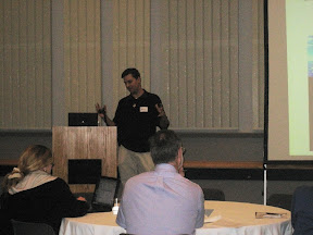 | Date: Nov 19, 2009 6:08 AM Number of Comments on Photo:0 |
Friday, November 27, 2009
Piano stairs - TheFunTheory.com - Rolighetsteorin.se
The same concept applies to science and technology education
http://www.youtube.com/watch?v=2lXh2n0aPyw&feature=youtube_gdata
Art Trembanis
CSHEL
Univ of Delaware
Wednesday, November 25, 2009
Pavilion Lake Fledermaus Video
Latest export from Fledermaus.
http://www.youtube.com/watch?v=IVGXwPauhnI&feature=youtube_gdata
Art Trembanis
CSHEL
Univ of Delaware
Radar Beats GPS In Court — Or Does It?
The lengths that will be gone to to fight a ticket...
November 7, 2009 5:14 AM
by Soulskill
Radar Beats GPS In Court — Or Does It?
TechnologyResource writes "More than two years ago in California, a police officer wrote Shaun Malone a ticket for going 62mph in a 45-mph zone. Malone was ordered to pay a $190 fine, but his parents appealed the decision, saying data from a GPS tracking system they installed in his car to monitor his driving proved he was not speeding. What ensued was the longest court battle over a speeding ticket in Sonoma county history. The case also represented the first time anyone locally had tried to beat a ticket using GPS. The teen's GPS pegged the car at 45 mph in virtually the same location. At issue was the distance from the stoplight — site of the first GPS 'ping' that showed Malone stopped — to the second ping 30 seconds later, when he was going 45 mph. Last week, Commissioner Carla Bonilla ruled the GPS data confirmed the prosecution's contention that Malone had to have exceeded the speed limit and would have to pay the $190 fine. 'This case ensures that other law enforcement agencies throughout the state aren't going to have to fight a case like this where GPS is used to cast doubt on radar,' said Sgt. Ken Savano, who oversees the traffic division. However, Commissioner Bonilla noted the accuracy of the GPS system was not challenged by either side in the dispute, but rather they had different interpretations of the data. Bonilla ruled the GPS data confirmed the prosecution's contention that Malone had to have exceeded the speed limit."
Read more of this story at Slashdot.
transportation
Art Trembanis
CSHEL
Univ of Delaware
Ghost ships of the black sea on NatGeo TV

Sent from my Verizon Wireless BlackBerry
Thursday, November 19, 2009
IMG00315.jpg

Sent from my Verizon Wireless BlackBerry
Wednesday, November 18, 2009
Storm breaches to form inlet at Fowler's Beach
Our friend Trevor pointed up to this home video showing the newly cut inlet at Fowler's Beach that formed during the November 2009 Nor'easter.
Monday, November 16, 2009
Underwater Glider Hunts, Records Cryptic Whales | Wired Science | Wired.com
Triangulate Your Position From the Ocean - Wired How-To Wiki
Sunday, November 15, 2009
AUV - November 2009
AUV - November 2009
University of Delaware scientists are helping develop the next generation of coastal research tools. One of those technologies is called an Autonomous Underwater Vehicle, or AUV.
Art Trembanis
CSHEL
Univ of Delaware
Tuesday, November 10, 2009
Some video links about marine magnetometers
Here is a video about the search for the civil war submarine the
Alligator...it includes our colleague Dwight Coleman from URI and IFE
http://www.youtube.com/watch?v=QRGW99QZoeE&feature=player_embedded
Alligator...it includes our colleague Dwight Coleman from URI and IFE
http://www.youtube.com/watch?v=QRGW99QZoeE&feature=player_embedded
and here is an introductory video about magnetometers by Ross Johnson
at Geometrics.
http://www.youtube.com/watch?v=r_C_uma9nzQ&feature=player_embedded
Friday, November 6, 2009
New computer/viz lab

Still need the new podium to complete the front of the room.
Sent from my Verizon Wireless BlackBerry
Tuesday, November 3, 2009
Merrill Center for AUV meeting

Sent from my Verizon Wireless BlackBerry
Sunday, October 11, 2009
CSHEL Coast Day 2009 Highlights


Coast Day 2009. http://gallery.me.com/arttrembanis#100160
We had hundreds of attendees at our booth in the
Coastal Tent where kids of all ages did the Build a Buoy (BaB)
activity (Courtesy Doug Levin @ NOAA CBO), attendees also had the
opportunity to drive one of our home built PVC ROvs (Aquabotz kit) and
control a VideoRay (courtesy Doug Levin). Also on display was our
Gavia AUV DORA and Matt Oliver's lab at the table next to us had their
Slocum glider on display. Thanks to everyone who helped out before,
during, and after the event.
Saturday, October 10, 2009
nsf.gov - News - The Abyss: Deepest Part of the Oceans No Longer Hidden- All Images - US National Science Foundation (NSF) - US National Science Foundation (NSF)
Nereus images from the Marianas Trench released.
http://www.nsf.gov/news/news_images.jsp?cntn_id=114913&org=NSF
Art Trembanis
CSHEL
Univ of Delaware
Wednesday, October 7, 2009
Tuesday, October 6, 2009
Data visualizations in Google Earth | Google Earth Blog
Thanks to Doug M. for this link about several recent cool applications of Google Earth for Marine and Earth Sciences.
Data visualizations in Google Earth | Google Earth BlogThursday, October 1, 2009
How Earth’s Hum Could Help Us Map Mars | Wired Science | Wired.com
http://www.wired.com/wiredscience/2009/10/hummingearth-2/
Art Trembanis
CSHEL
Univ of Delaware
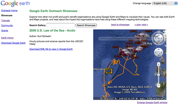
Healy in Google Earth Showcase
September 30, 2009 9:30 PM
by Kurt
LOTS in Google Earth Showcase
<a href="http://bit.ly/USCGCHealy">USCGC Healy</a> and <a href="http://earth.google.com/outreach/showcase.html#kml=2009_U.S._Law_of_the_Sea_-_Arctic">Google Earth Outreach Showcase - 2009 U.S. Law of the Sea - Arctic</a> <br /><br /> <img title="Healy in the Google Earth Browser Plugin" withgrayborder="True" src="http://schwehr.org/blog/attachments/2009-09/2009healy-googleearth-showcase-2.png"/> <br /><br /> <img title="Healy on the Outreach Showcase" withgrayborder="True" src="http://schwehr.org/blog/attachments/2009-09/2009healy-googleearth-showcase-1.png"/>
Art Trembanis
CSHEL
Univ of Delaware
Friday, September 25, 2009
Floodgates Might Not Save Venice
September 21, 2009 5:13 PM
by dotdotdotdotdotdotdotdotdotdotdotdotdotdotdotdotdotdotdotdot
Floodgates Might Not Save Venice
The construction of mobile floodgates aims to safeguard the 1,300-year-old island city of Venice. It's an ambitious engineering project, but some scientists say it may not be sufficient to protect Venice from rising sea levels due to climate change. Venice rose from mudflats in the middle of a lagoon which forms the largest wetland in the Mediterranean. One of the world's most endangered cities, it has been subject to increasing flooding due to sinking land — but also to rising sea levels.
Art Trembanis
CSHEL
Univ of Delaware
New Cases!
Yesterday our new set of AUV module cases arrived and Adam quickly set about customizing each case to fit the modules. This will make travel and transportation much easier.


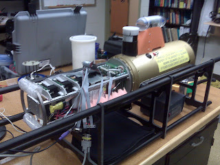
Wednesday, September 23, 2009
Another image of the MIMO system

array.

Monday, September 21, 2009
Oct. 4 Coast Day lectures highlight environmental issues
http://www.udel.edu/udaily/2010/sep/coastday092109.html
Art Trembanis
CSHEL
Univ of Delaware
Thursday, August 27, 2009
Heezen Tharp Map in Google Earth!

when I was an undergrad, one of the projects I worked on was to gather
maps and measurements of the barrier islands of the world...no biggie
small islands from the ENTIRE globe! Mind you these were in the days
before Google Earth so we had to use REAL maps. In order to do the
project I spent several weeks camped out at the Library of Congress
Maps Division, *side note: you owe it to yourself to check this place
out some time*. Unlike other libraries at the LoC you don't just
wander through the stacks looking for the material you are after oh no
only the librarians do that so instead you have to present them with
lists of the material you want. At the time the best available global
coverage high resolution maps were 1:20,000 maps from WWII they were
called JOGs for Joint Operation Graphics they also had another
"recently" acquired (thank you end of the Cold War) global map set
from the Russians. The Russian maps were in Cyrillic but since I
wasn't interested in place names just islands these were fine. After
several days of drawing maps from various different map sets, one of
the very helpful librarians pulled me aside to give me a glimpse of
the back room- first to impress upon me the yeoman's task that I had
been asking them to do- you see they were having to pull maps from
opposite corners of their mapping space and they have literally acres
of space down there. The second thing the librarian did was to ask
"You're an Oceanographer right?" One always wonders what is coming
next with a question like that but I said "Well yes I'm studying to be
one". The librarian then asked if I knew who Bruce Heezen and Marie
Tharp were. Know who they are well of course every Oceanography,
Geology, and Geography department in the planet used to have a copy of
their maps of the seafloor on the walls. Turns out the LoC had
recently acquired a vast collection of the maps and the precursor
mylars that went into making those maps. I was quickly showed to an
area in the back room where tables and boxes where piled in a chaotic
fashion, a huge mish mash of maps and books and correspondence all
related to this mammoth work. This experience kicked off a long
standing interest in both the maps and the map makers that continues
to this day. I later went to visit the archives of the Smithsonian
where they had some 60+ boxes of archive material for Heezen, one of
the founding titans in modern geological oceanography.
Years later first when playing with Fledermaus and then again in
Google Earth I had this notion that wouldn't it be great to bring the
old Heezen Tharp map into one of these visualization systems and
compare the maps of today with what Heezen and Tharp produced- they
had in comparison a very limited and scant data set from which to
build their extrapolated map. Well it seems others had the same idea
too as I just found this layer in Google Earth that includes the
Heezen Tharp map. What a great teaching resource! What a marvelous
piece of mapping history.
USCG Healy expedition in Google Earth and on NOAA OER


under the Ocean Layer. Click on "Expeditions" and fly up to the arctic
for a peak. If you click on the expedition icon you'll see the latest
image from the aloft camera on the Healy. Keep tuning in for more
updates as the Healy working with the Louis S. St Laurent push north.
There is also an expedition summary on the NOAA Ocean Exploration and
Research, Exploration page
http://oceanexplorer.noaa.gov/explorations/09ecs/welcome.html
Tuesday, August 25, 2009
In Search of the Asian Clam...
Researchers at the UC Davis Tahoe Environmental Research Center invited Gavia operators from the University of British Columbia, University of New Hampshire, and University of Delaware to Lake Tahoe in search of the invasive Asian clam that is becoming more prevalent in these waters. In a true collaborative effort between UBC and UDel/UNH AUV teams, the Gavia was run with the UBC control, props, and nose module and the UDel/UNH positioning system and Geoswath, with the battery modules of each being swapped in to extend run time. Due to the transparency of lake waters of up to 70m, our primary objective was to photograph the lake bed to determine clam distributions. The clams threaten the clarity of the lake by increasing nutrient levels in the lake, encouraging a thick algae growth to carpet the bottom. Consequently we also collected water quality measurements including CDOM, backscatter, chlorophyll concentration, and CTD during these missions.
 The Gavia ready for night swimming in the quiet waters of Lake Tahoe, is trimmed with incompressible foam needed to provide lift at the nose in the freshwater.
 Working on the boat from dusk until dawn had its rewards: beautiful sunrises on the lake!
Our first week of missions entailed circumnavigating the lake along the 5m contour at an altitude of 2.5m. In order to optimize the clam detection algorithm we wrote, which targets the white color of dead clams, we ran missions at night to avoid sunlight reflections on the bottom, which would be classified as clams. We also avoided boat traffic by executing missions at night. Night work in clear water made tracking the Gavia easy, as we just followed the strobe/tower lights. This also allowed us to precisely time when the camera card was full by having a stopwatch that started when the strobe started and stopped when it turned off. We captured 2 hours of photos before pulling the Gavia back aboard and transferring the photos to the Toughbook via LAN.
An image of the bed reveals sandy sediments with an abundance of clams and algal growth.
 Our image-processing algorithm is shown below with the original image in the top right, initial clam detections in the top left, and advanced clam detection in the bottom right.
 Mission planning was the most challenging task as the perimeter of the lake is full of erratics. Our most successful technique for mission planning included using Fledermaus to locate waypoints on the 5m contour from the multibeam data Mayer et al. published, Control Center to plot the points, and GoogleEarth to check for erratics. Though tedious this has allowed us to run 2-hour missions (to fill the camera card) without having to stop and restart due to obstacles. This afforded us time to watch the amazing Perseid meteor showers.
A glance at the Lake Tahoe shoreline by day reveals the dangers of flying the Gavia through shallow waters!
 At the end of the first battery pack our team transformed from Gavia-/star- gazers to a professional pit-crew able to download data, change the Gavia battery (which entailed removing a CTD, buoyant trim, cleaning o-rings, and carefully aligning the modules) with great efficiency.
The circumnavigation was completed by the start of our second week and yielded important information on clam presence around the lake. The remainder of our missions was spent surveying areas with high clam concentrations using two strategies: 1. Contour following at 10-15m depth intervals by running shorter survey lines parallel to contours as in the circumnavigation. 2. Running survey lines perpendicular to contours from about 5m to 70 m depth or to the edge of the shelf break. Bottom-tracking proved difficult during these missions, the Gavia would often abort missions because she was unable to reach a waypoint in time. Another difficulty was maximizing the number of useable images we could collect in missions that cut across contours. Flying across contours was challenging because the Gavia has trouble bottom-tracking along steep areas, which are prevalent along the basin walls. Slopes of greater than 10 to 15 degrees were common and because of this we ran more, shorter missions. We would send Gavia perpendicular to the contours at 1.5 m altitude and then make the return leg constant depth of 2 m to avoid ploughing the AUV into the steep slopes. Because of the many sites of interest and the relatively time-consuming nature of this mode of operation, we ran about 2-4 lines per site.
Project PI, Marion Wittmann, and boat captain, Brant Allen of UC Davis enjoying the night on Tahoe.
 Throughout our two weeks the Gavia covered more ground than on any previous research trip. We found clams at greater depths (80 m) than previously discovered and also imaged algal mats and the pond liner used to control clam populations along the south shore. The only disappointment is that we did not have the time to run survey lines with sufficient overlap to obtain quality Geoswath data. Leaving Tahoe with the knowledge that Gavia has collected an abundance of data and successfully contour-followed and run across steep contours, two seemingly impossible survey goals, is extremely rewarding. This was a spectacular end to the Gavia’s and my first full field season with Team CSHEL!
 Andrew, me, and Alex keeping warm in the cold dawn hours on Lake Tahoe.
Monday, August 10, 2009
Bottom mount is home again!


bottom mount aboard the RV Captain White.
Thanks to all involved.
Tuesday, August 4, 2009
Dale Stokes seminar on YouTube includes Bonaire adventures
Here is a link to a YouTube video featuring our friend and colleague Dale Stokes talking about his work!
Thursday, July 23, 2009

Saturday, July 18, 2009
Congratulations Stephanie

A wonderful accomplishment for Stephanie who will continue on in our PhD program.
Here Stephanie, Nicole, Hilary, and Ella all join in for a post-defense dinner celebration.
Kudos Steph!!
Sent from my Verizon Wireless BlackBerry
Tuesday, July 14, 2009
Improvised sun shade

Sent from my Verizon Wireless BlackBerry
ROV Operations!

Sent from my Verizon Wireless BlackBerry
CTD data aboard RV Sharp

Sent from my Verizon Wireless BlackBerry
Friday, July 10, 2009
ROV pool day!

After hours of building and wiring today they finally get to see how their ROVs maneuver.
We also have the little Video Ray ROV here (courtesy of Doug Levin) for the students to try their hand at a real commercial unit and compare the performance and features.
Sent from my Verizon Wireless BlackBerry
Wednesday, July 1, 2009
MIMO module assembly

Sent from my Verizon Wireless BlackBerry
Monday, June 29, 2009
MIMO module takes shape


Badiey. I was able to see the newly completed electronics payload
stack that Jing has been working on feverishly. In the first photo
here you can see clearly the 3 amplifier boards for the WHOI
micromodems. It is a tight squeeze to get everything into the payload
module always a case of trying to get 10 pounds of electronics into a
5 pound space. Not only has the electronics module been completed but
the team managed to come up with a mounting configuration for the
transducers inside the flooded section. In the second photo you can
see the end cap that provides bulkhead connector access between the
dry electronics module and the flooded section where the transducers
reside. 3 WHOI micromodem transducers are visible. Also there is a
port for the hydrophone array (up to 8 hydrophones can be supported).
This week the team will conduct bench top tests and we then hope to
test it in the UD pool next week then out in the reservoir and before
finding a ready site for tests out in the ocean.
The applications for this system are really exciting and I for one
can't wait to get into the testing phase.
Subscribe to:
Comments (Atom)