Monday, May 30, 2011

The Innovative Necessities of War

Le systeme D

starMake: Online
May 30, 2011 6:15 PM
by Gareth Branwyn

The Innovative Necessities of War

You've all heard the amazing stories of soldiers hacking on the battlefield — the stories of fox hole radios, scrap armor, and anti-IED tech (that must constantly change as IED tech itself adjusts to the hacks). In time for this year's Memorial Day, the Army announced that they are going to start giving awards to recognize soldiers for their "Battlefield Innovations." Jeez, what took them so long? They're calling it the Soldier Greatest Inventions Awards.

I love the amazing stories of some of these battlefield innovations, some done at the risk of a soldier (or POW's) life. There are all of the pee hacks, for instance — peeing on machine gun barrels in WWI to cool them down, peeing on stuck gun mechanisms in WWII to unfreeze them from the winter cold, and the most amazing one, of Jewish prison workers secretly peeing on V2 control mechanisms to create time-released rusting which would remain undetected during assembly, but cause a malfunction by the time the rocket hit the pad. Recently, there's been the cat and mouse "game" between US forces and insurgents with tricks like suspending a toaster from a pole in front of a truck to cause heat-triggered IEDs to detonate early.

What are some of the more clever battlefield innovations that you've heard about?

hacks Holiday projects


Dr. Art Trembanis
CSHEL
109 Penny Hall
Department of Geological Sciences
The College of Earth, Ocean, and Environment
University of Delaware
Newark DE 19716
302-831-2498

"Education is not the filling of a pot, but the lighting of a fire." -W. B. Yeats

Commemorate Memorial Day with Google Earth

starGoogle Earth Blog
May 30, 2011 8:13 AM
by Google Earth Blog

Commemorate Memorial Day with Google Earth

On this Memorial Day, we offer you a few tools to help honor those who gave it all.

As we've done the last few years, we encourage you to check out Sean Askay's Map the Fallen project. Using his KML file, you can learn about many of the people that have lost their lives in recent US military duty.

Map of the Fallen in Google Earth

Another neat item to check out today is the US Medal of Honor collection that we first showed you in 2008. It was created by user 'Up_The_Spurs' from the Google Earth Community. You can download the KMZ and view the birthplaces, rank, organization, location of deed and citation for each winner.

medal-of-honor.jpg

If you know of any other great Memorial Day resources for Google Earth, please leave a comment and let us know.

Sightseeing


Dr. Art Trembanis
CSHEL
109 Penny Hall
Department of Geological Sciences
The College of Earth, Ocean, and Environment
University of Delaware
Newark DE 19716
302-831-2498

"Education is not the filling of a pot, but the lighting of a fire." -W. B. Yeats

Sunday, May 29, 2011

BBC News - Bubbling sea signals severe coral damage this century

http://www.bbc.co.uk/news/science-environment-13569442


Dr. Art Trembanis
CSHEL
109 Penny Hall
Department of Geological Sciences
The College of Earth, Ocean, and Environment
University of Delaware
Newark DE 19716
http://cshel.geology.udel.edu
302-831-2498

"Education is not the filling of a pot, but the lighting of a fire." -W. B. Yeats

Friday, May 27, 2011

Pirate Pictures: Captain Morgan's Cannons Found?

Photos by our pal Donnie Reed! Go Donnie!!
http://news.nationalgeographic.com/news/2011/05/pictures/110524-pirates-captain-morgan-cannons-rum-science-panama/#/captain-morgan-cannons-recovered-diver-lifting_35904_600x450.jpg

Don't miss Sony's Project Shiphunt, a fun game using Google Ocean

Looks like fun though I still prefer the real thing...reminds me we need to get back tothat ship we discovered off Cape Henlopen.

starGoogle Earth Blog
May 27, 2011 7:59 AM
by Google Earth Blog

Don't miss Sony's Project Shiphunt, a fun game using Google Ocean

We've covered a lot of games that have been created using Google Earth (and/or the Google Earth Plug-in) as the playing field. We wrote up an overview of many of them last year, and since then we've seen a few other great ones like "Drive the A-Team Van" and "Ships 1.5". However, I don't think I've yet seen a game that makes such extensive use of Google Ocean as I've seen with Sony's new Project Shiphunt.

sony-sub.jpg

The game is very well done and certainly quite challenging. You can play it at discover.sonystyle.com/shiphunt or watch the trailer below for more.

Have you tried it yet? Any luck finding some ships?


GE Plugin


Dr. Art Trembanis
CSHEL
109 Penny Hall
Department of Geological Sciences
The College of Earth, Ocean, and Environment
University of Delaware
Newark DE 19716
302-831-2498

"Education is not the filling of a pot, but the lighting of a fire." -W. B. Yeats

Tuesday, May 24, 2011

Grimsvötn’s ash cloud visualized in Google Earth

starOgle Earth
May 24, 2011 6:38 AM
by Stefan Geens

Grimsvötn's ash cloud visualized in Google Earth

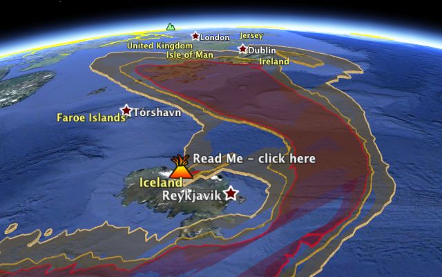
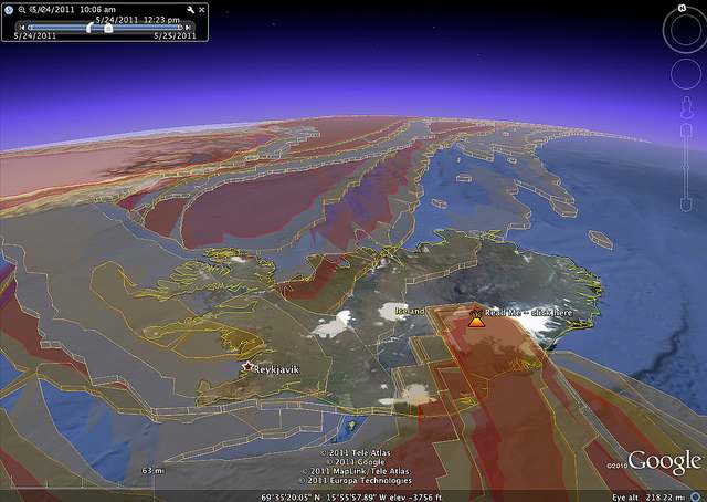
With erupting Icelandic volcanoes seemingly becoming an annual event, Adam Burt has overhauled his ash-cloud visualization tool for Google Earth, which he first made for Eyjafjallajökull's eruption in June of 2010. Based on data gleaned every six hours from the UK Met office, the resulting network link visualizes ash density from Grimsvötn at different times and airspace heights, and can be played as an animation. Here it is — open in Google Earth.

Interesting to see how at different heights, the ash heads off in completely different directions.

Uncategorized


Dr. Art Trembanis
CSHEL
109 Penny Hall
Department of Geological Sciences
The College of Earth, Ocean, and Environment
University of Delaware
Newark DE 19716
302-831-2498

"Education is not the filling of a pot, but the lighting of a fire." -W. B. Yeats

Sunday, May 22, 2011

Pix4D can automatically turn your 2D aerial photos into 3D

Wow this would be awesome to try and do with AUV imagery.

From Google Earth
http://feedproxy.google.com/~r/GoogleEarthBlog/~3/Na9q36_crZ8/pix4d_can_automatically_turn_your_2.html

Blue Marble in the year 3000

From Google Earth
http://feedproxy.google.com/~r/GoogleEarthBlog/~3/GVVe8Ek7Nfk/blue_marble_in_the_year_3000.html

LiDAR views of the Carolina Bays

This is neat and something I've been thinking about for a local student project to use the state lidar data to look at Carolina bays in DE.

From Google Earth
http://feedproxy.google.com/~r/GoogleEarthBlog/~3/YwBqmrLnMo8/lidar_views_of_the_carolina_bays.html


Dr. Art Trembanis
CSHEL
109 Penny Hall
Department of Geological Sciences
The College of Earth, Ocean, and Environment
University of Delaware
Newark DE 19716
http://cshel.geology.udel.edu
302-831-2498

"Education is not the filling of a pot, but the lighting of a fire." -W. B. Yeats

Saturday, May 21, 2011

Cyber Stalking the EPA Bold cruise

Thanks to a reminder from Doug to look for the AIS feed I went to the MarineTraffic.com site this evening to check up on where he and Nicole and the rest of the Bold team is today. Looks like they are working in a series of onshore/offshore transects just off Sandbridge VA. Looking forward to continuing to monitor their progress especially when they get out to the DE offshore windfarm site.

Good luck and fair winds to the scientists and crew of the Bold.

Friday, May 20, 2011

NOAA and partners explore the hidden world of the maritime Maya

http://www.noaanews.noaa.gov/stories2011/20110518_maritimemaya.html


Dr. Art Trembanis
CSHEL
109 Penny Hall
Department of Geological Sciences
The College of Earth, Ocean, and Environment
University of Delaware
Newark DE 19716
http://cshel.geology.udel.edu
302-831-2498

"Education is not the filling of a pot, but the lighting of a fire." -W. B. Yeats

Wednesday, May 18, 2011

Tuesday, May 17, 2011

Conch Reef Key Largo, Florida

Upon arriving in rainy Key Largo, Florida after a 23 hour car ride we were allowed a few hours of sleep before unloading all the equipment, organizing and preparing for the first day at sea (5/2).  Later that night (5/1) Art, Bryan Keller, Alex Forrest and I gave brief presentations on our personal areas of expertise regarding the NEEMO project.  My presentation mainly involved the geology corresponding to the environment of Conch Reef and around the Aquarius habitat.  Also, I touched on the local fauna and other living things.

Approximately at 0800 hrs we set off the coast of Key Largo to begin our copious research involving the bathymetry around the Aquarius underwater lab.  Aboard the R/V George Bond there was myself, Art, Alex Forrest, Doug Miller, Jonathon Gutsche, Bryan Keller, VAL, and our ship captain Ryan.  The first day of project we had planned and completed two successful missions for the AUV Gavia, "Dora".  The areas of focus were mainly the shallow areas (relatively northwest of the habitat).  Simultaneous to the AUV missions multiple CTD senors were taken.   

The following day differed from the previous (involving my personal involvement, Jonathon and I stayed on land in order to process the data we collected on Monday.  I had prior experience with the software "SonarWiz," not not much with the other programs we used that day.  At first I was able to observe how to (generally) complete data processing in GeoSwath, Feludermause, and 

On Wednesday we were all back out on the R/V Bond (minus Bryan who was the "in house data processor" for the day). 

--
Lyle de la Rosa
Coastal and Marine Geosciences
College of Earth, Ocean, and Environment
University of Delaware
Club Water Polo Secretary
(215)873-9014

Scheduling the Unknown

http://www.astrobio.net/exclusive/3972/scheduling-the-unknown

Sunday, May 15, 2011

Artist Creates Intricate Portraits Out of Old Maps | Underwire | Wired.com

Weird and kinda cool

http://m.wired.com/underwire/2011/05/nikki-rosato-map-portraits/?utm_source=feedburner&utm_medium=feed&utm_campaign=Feed%3A+wired%2Findex+%28Wired%3A+Index+3+%28Top+Stories+2%29%29&utm_content=Google+Feedfetcher


Dr. Art Trembanis
CSHEL
109 Penny Hall
Department of Geological Sciences
The College of Earth, Ocean, and Environment
University of Delaware
Newark DE 19716
http://cshel.geology.udel.edu
302-831-2498

"Education is not the filling of a pot, but the lighting of a fire." -W. B. Yeats

Weather Blog : Old River Control Structure and Flood of 2011

A good read about the Old River Control Structure.  Visited it during a grad school Mississippi River field trip back in ~2002.  Remember asking an engineer there what would happen "when" (not if) the river breached and bypassed the structure..."we'll just up and move it back" was the reply...


http://www.wunderground.com/blog/JeffMasters/article.html?entrynum=1801

Friday, May 13, 2011

Exclusive Book Excerpt: Sex, Drugs and Sea Slime

Obviously the must read summer book.

http://feeds.wired.com/~r/wired/index/~3/wKxQUCwwtQw/

Predicting Sea Surface Salinity from Space

starOcean Bytes
May 13, 2011 12:56 PM
by Erick Geiger

Predicting Sea Surface Salinity from Space

The simplest definition of salinity is how salty the ocean is. Easy enough, right? Why is this basic property of the ocean so important to oceanographers? Well, along with the temperature of the water, the salinity determines how dense it is. The density of the water factors into how it circulates and mixes…or doesn't mix. Mixing distributes nutrients allowing phytoplankton (and the rest of the food web) to thrive. Mixing also distributes heat between the poles of the earth's poles and the equator which can affect climate. Climate change is important to oceanographers; therefore, salinity is important to oceanographers.

Spring Salinity Climatology for the Chesapeake

Spring Salinity Climatology for the Chesapeake

Salinity doesn't vary that much in the open ocean, but it has a wide range in the coastal ocean since the coast is where fresh water from rivers and salt water in the ocean mix. Our measurements of salinity along the coast provide us with a picture of how this complex mixing between fresh and salt water occurs and also affects the local biology, physics, and chemistry of the seawater. Our picture, however, is very small. Salinity data is collected by instruments on ships, moorings, and more recently underwater vehicles such as gliders. While these measurements are trusted to be very accurate, their spatial and temporal resolution leaves much to be desired when compared to say near-daily sea surface temperature estimated from a satellite in space.

Why can't we do the same thing we do with salinity then? Let's just measure salinity from a satellite and get the big picture. Well, it's not as simple, but it is possible. NASA's Aquarius mission http://aquarius.nasa.gov/ scheduled to launch this year is taking advantage of a set of three advanced radiometers that are sensitive to salinity (1.413 GHz; L-band) and a scatterometer that corrects for the ocean's surface roughness. With this they plan on measuring global salinity with a relative accuracy of 0.2 psu and a resolution of 150 km. This will provide a tremendous amount of insight on global ocean circulation, the water cycle, and climate change. Awesome, global salinity problem solved. What about coastal salinity? What if I wanted to know the salinity in the Chesapeake Bay? That's much smaller than 150 km wide.

That's where my project comes in. It involves NASA's MODIS-Aqua satellite (conveniently already in orbit: http://modis.gsfc.nasa.gov/), ocean color, and a basic understanding of the hydrography of the coastal Mid-Atlantic Ocean. Here's how it works. We already know a few things about the color of the ocean, that is, the sunlight reflecting back from the ocean measured by the MODIS-Aqua satellite. We know enough that we can estimate the concentration of the photosynthetic pigment chlorophyll-a. So not only can we see temperature from space, but we can estimate phytoplankton biomass too! Anyway, there are other things in the water that absorb light besides phytoplankton and alter the colors we measure from the satellite.

Spring Salinity Climatology for the Mid-Atlantic

Spring Salinity Climatology for the Mid-Atlantic

We group these other things into a category we call colored dissolved organic material or CDOM. CDOM is non-living detritus in the water that either washes off from land or is generated biologically. It absorbs light in the ultraviolet and blue wavelengths, so it's noticeable from satellites. In coastal areas especially, its main source of production is runoff from land. So, CDOM originates from land and we can see a signal of it from satellites that measure color. What's that have to do with salinity?

You may have already guessed it, but water from land is fresh. So, water in the coastal ocean that is high in CDOM should be fresher than surrounding low CDOM water. That's our basic understanding of the hydrography of the coastal Mid-Atlantic Ocean, how it relates to ocean color, and why we need the MODIS-Aqua satellite to measure it. With this information, I compiled a lot of historic salinity data from ships (over 2 million data points) in the Mid-Atlantic coastal region (Chesapeake, Delaware, and Hudson estuaries) and matched it with historic satellite data from the MODIS-Aqua satellite. Now I have a dataset that contains ocean color and salinity. Using a non-linear fitting technique, I produced an algorithm that can predict what the salinity of the water should be given a certain spectral reflectance. I made a few of these algorithms in the Mid-Atlantic, one specifically for the Chesapeake Bay. It has an error of ±1.72 psu and a resolution of 1 km. Not too bad, but there's always room for improvement. Even so, this is an important first step for coastal remote sensing of salinity. An algorithm like this can be used to get salinity data as often as sea surface temperature. That's pretty useful. Now we just need to apply it and make it better.

Climatologies of salinity can be downloaded here: http://modata.ceoe.udel.edu/dev/egeiger/salinity_climatologies/

Research Vessels/Ships Satellite Science and Technology Sensors NASA NOAA Salinity satellite Sensor Space UD


Dr. Art Trembanis
CSHEL
109 Penny Hall
Department of Geological Sciences
The College of Earth, Ocean, and Environment
University of Delaware
Newark DE 19716
302-831-2498

"Education is not the filling of a pot, but the lighting of a fire." -W. B. Yeats

Conch Reef Survey for NASA’s NEEMO 15 Project | Ocean Bytes

Nice article on oceanbytes about our NEEMO mission work. Thanks Doug!

http://www.oceanbytes.org/2011/05/11/conch-reef-survey-for-nasas-neemo-15-project/

Tuesday, May 10, 2011

May 9, 1941: German Sub Caught With the Goods | This Day In Tech | Wired.com

http://m.wired.com/thisdayintech/2011/05/0509U-110-captured-enigma-machine/?utm_source=feedburner&utm_medium=feed&utm_campaign=Feed%3A+wired%2Findex+%28Wired%3A+Index+3+%28Top+Stories+2%29%29&utm_content=Google+Feedfetcher


Dr. Art Trembanis
CSHEL
109 Penny Hall
Department of Geological Sciences
The College of Earth, Ocean, and Environment
University of Delaware
Newark DE 19716
http://cshel.geology.udel.edu
302-831-2498

"Education is not the filling of a pot, but the lighting of a fire." -W. B. Yeats

May 10, 1960: USS Triton Completes First Submerged Circumnavigation

starWired Top Stories
May 10, 2011 7:00 AM
by Tony Long

May 10, 1960: USS Triton Completes First Submerged Circumnavigation

May 10, 1960: A U.S. Navy sub surfaces after nearly 61 days, completing the first submerged circumnavigation of the Earth.


Dr. Art Trembanis
CSHEL
109 Penny Hall
Department of Geological Sciences
The College of Earth, Ocean, and Environment
University of Delaware
Newark DE 19716
302-831-2498

"Education is not the filling of a pot, but the lighting of a fire." -W. B. Yeats

Panorama of VAST lab

Here is a panorama of the VAST lab that I created with the photoaf app on my Droid2.

New Jersey Beach Replenishment: Is it Worth It? | Radio Times | WHYY

Yesterday's Radio Times segment was all about beach nourishment and included commentary by our colleague Andy Coburn of PSDS.

http://whyy.org/cms/radiotimes/2011/05/09/new-jersey-beach-replenishment-is-it-worth-it/

NASA - NASA NEEMO Live

Link to the NEEMO live webstream.
http://www.nasa.gov/mission_pages/NEEMO/neemolive.html

Cosmic Log - NASA tries out an undersea 'asteroid'

Story yesterday on MSNBC about the NEEMO XV engineering mission.  Thanks Doug M for the heads up.
http://cosmiclog.msnbc.msn.com/_news/2011/05/09/6613793-nasa-tries-out-an-undersea-asteroid

Sunday, May 8, 2011

Rules from The Tinker’s Handbook

Good rules with applicability to any technical venture.

starMake: Online
May 8, 2011 8:30 PM
by Gareth Branwyn

Rules from The Tinker's Handbook

For eight days, David Malki's Wondermark webcomic was turned into the Tinker's Handbook, a loving send-up of MAKE and maker culture. He ended the "handbook" with this wonderful Maker's Bill of Rights-like "codified set of the builder's, crafter's, maker's rules. [via Boing Boing, by way of MAKE's Laura Cochrane]

Wondermark's Nominally-Essential Tinker's Handbook: The magazine for people who cannot leave well enough alone

Makers Retro Toolbox steampunk webcomic


Dr. Art Trembanis
CSHEL
109 Penny Hall
Department of Geological Sciences
The College of Earth, Ocean, and Environment
University of Delaware
Newark DE 19716
302-831-2498

"Education is not the filling of a pot, but the lighting of a fire." -W. B. Yeats

The Diving Spudmarine

http://blog.makezine.com/archive/2011/05/the-diving-spudmarine.html

Monday, May 2, 2011

Day one NEEMO

AUV back on board and heading home after a successful first day mapping Conch Reef.