This is hella cool and a really neat teaching resource. Kudos Kurt!
August 30, 2010 12:53 PM
by Kurt
Plate boundaries lab - In Google Earth
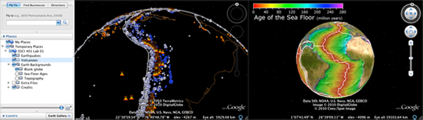
Students will be doing the lab today to kick off Margaret's ESCI401 here at UNH. <br /><br /> <a href="http://vislab-ccom.unh.edu/~schwehr/Classes/2010/esci401/lab01/lab01.kmz">lab01.kmz</a> [9MB] or <a href="http://tinyurl.com/esci401-lab01">http://tinyurl.com/esci401-lab01</a>. <br /><br /> <img title="Plate boundaries in Google Earth" withgrayborder="True" src="http://schwehr.org/blog/attachments/2010-08/lab01.png"/> <br /><br /> Created by Kurt Schwehr and Margaret Boettcher for the ESCI 401 course at the University of New Hampshire, August 2010. Lab adapted from from <a ref="http://terra.rice.edu/plateboundary/home.html">Dale Sawyer's Discovering Plate Boundaries</a>. Sources of material: <ul> <li>Earthquakes are from the <a href="http://earthquake.usgs.gov/monitoring/anss/">ANSS</a> (Advanced National Seismic System) Catalog</li> <li>Volcanoes are from the <a href="http://www.volcano.si.edu/world/">Smithsonian Volcano</a> <a href="http://www.volcano.si.edu/world/summary.xls">Excel Workbook</a></li> <li>Topography and seafloor age images are from NOAA's NGDC: <a href="http://sos.noaa.gov/datasets/Land/sea_floor_age.html">Science on a Sphere (SOS) - Sea Floor Age</a>.</li> <li>The shore line is the <a href="http://rimmer.ngdc.noaa.gov/coast/">World Coast Line (WCL) for 1:5,000,000</a></li> <li>Plate boundaries are derived from Carlton's <a href="http://serc.carleton.edu/files/eet/seismicwave/plates_quakes_countries.zip">plates_quakes_countries.zip</a></li> </ul> <a rel="license" href="http://creativecommons.org/licenses/by-nc-sa/3.0/"><img alt="Creative Commons License" style="border-width:0" src="http://i.creativecommons.org/l/by-nc-sa/3.0/88x31.png" /></a><br /><span xmlns:dc="http://purl.org/dc/elements/1.1/" href="http://purl.org/dc/dcmitype/InteractiveResource" property="dc:title" rel="dc:type">ESCI 401 Lab 1 - A Plate Tectonics Jigsaw Puzzle - Google Earth Visualization</span> by <a xmlns:cc="http://creativecommons.org/ns#" href="http://schwehr.org/" property="cc:attributionName" rel="cc:attributionURL">Schwehr</a> and <a href="http://www.unh.edu/esci/people/boettcher-m.html">Boettcher</a> is licensed under a <a rel="license" href="http://creativecommons.org/licenses/by-nc-sa/3.0/">Creative Commons Attribution-NonCommercial-ShareAlike 3.0 Unported License</a>. <br /><br /> The very rough source code that I used to create the lab is available: <a href=" http://vislab-ccom.unh.edu/~schwehr/Classes/2010/esci401/lab01/esci401-lab01-20100830.tar.bz2">esci401-lab01-20100830.tar.bz2</a>. I used this code to generate basic files, but I did a lot of hand tuning to get the final results.
No comments:
Post a Comment